For a century, engineers perfected moving stormwater into rivers as fast as possible. Now those rivers are returning the favor, flooding cities, and the proposed solution is often to pump water back into the same rivers that are already overflowing. We built a closed-loop problem.
Let me paint you a picture.
For the better part of the last hundred years, civil engineers, planners, and well-meaning city officials across the world have been laser-focused on a single, noble mission: get rainwater off streets and into rivers as fast as humanly possible. Catch basins, storm drains, concrete-lined channels, culverts the size of subway tunnels. Billions of dollars and generations of engineering talent, all dedicated to building what is essentially a giant, very expensive conveyor belt pointed squarely at the nearest waterway.
It worked beautifully. We got very good at it.
So good, in fact, that rivers started getting the message loud and clear.
Here's what the textbooks don't warn you about: rivers have a long memory and absolutely zero sense of humor about their floodplains. Those flat, fertile, conveniently located stretches of land adjacent to waterways that we've been enthusiastically building cities on for millennia? Rivers didn't stop considering those areas theirs just because we poured concrete over them. They've been patiently waiting, receiving our accelerated runoff deliveries with something approaching geological patience, and quietly planning.
Now they're planning their next move. And their next move is your downtown.
What we're witnessing in flood-prone cities today is nature executing the world's most inevitable return policy. We shipped the water. The river is returning it. And unlike Amazon, it doesn't offer tracking information or a convenient drop-off window. It just shows up, usually at 3 AM during a major storm event, measured in cubic feet per second and absolutely indifferent to our zoning regulations.
Now here's where the irony graduates from merely amusing to genuinely spectacular.
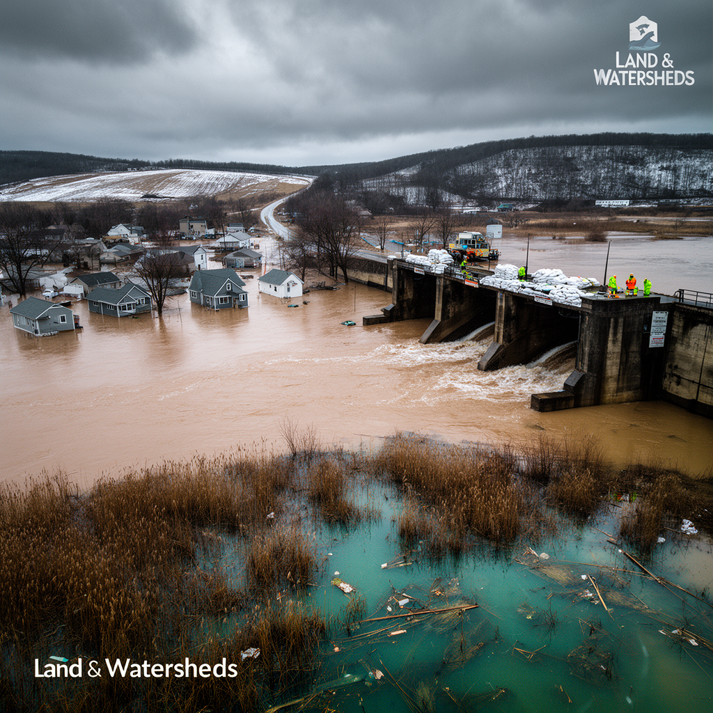
When rivers overflow into cities, the proposed solution that keeps surfacing in emergency management discussions goes something like this: use the storm drainage system to pump the floodwater back into the river.
Let that sink in for a moment. Please, take your time.
We want to use the infrastructure we built to move water toward rivers to move water away from rivers. We've essentially designed a system that was optimized in one direction, and we're now asking it to run in reverse because the river decided to renegotiate the original agreement.
This is the hydraulic equivalent of trying to use a vacuum cleaner as a leaf blower. Technically not impossible, but you are very much fighting the fundamental physics of the device, the operating manual, and several decades of design intent all at once.
Catch basins are intake structures. They catch water flowing toward them. Asking them to serve as flood evacuation valves during a river backwater event is a bit like asking the office building's front door to also function as the emergency exit when the lobby is already underwater. The geometry of the situation is not on your side.
Step back and look at the full system and you start to see something almost elegant in its dysfunction. We accelerated runoff into rivers, which increased peak flows, which expanded floodplains, which flooded cities, which prompted calls to pump water back into rivers, which are already running high because of all the accelerated runoff we've been sending them.
We built a closed-loop system. A water ping-pong table. And we're playing both sides simultaneously, losing on both ends, and acting surprised every single time.
The river, for its part, is not surprised. Rivers don't get surprised. They just have more discharge than the downstream cross-section can handle, and they behave accordingly. No drama, no committee meetings, no environmental impact assessments required. Just water finding the path of least resistance, which, inconveniently, is often through your neighborhood.
Here's the thing that keeps hydrologists up at night, and should probably keep urban planners up at night too: rivers predate our spreadsheets by a considerable margin. The Mississippi River has been working out its flood routing for about 2.6 million years. The Amazon has had roughly 11 million years of practice. Puerto Rico's karst rivers carved their channels through limestone before anyone was around to assign them a Rational Method runoff coefficient.
They are not impressed by our calculations. They are not persuaded by our design standards. And they are absolutely, categorically uninterested in the fact that the 100-year flood event we designed our infrastructure for was calibrated using rainfall records from before the climate shifted.
When a river wants its floodplain back, it doesn't submit a permit application to DRNA. It doesn't request a variance from the municipality. It simply arrives, with everything we've been faithfully sending it, plus whatever it picked up from upstream, plus the accumulated debt of a century of watershed development. It arrives with interest, and it stays until it decides to leave.
Q: Why does water return to cities during floods?
A: Rivers reclaim their historical floodplains. When cities occupy that space and rivers receive accelerated urban runoff, flooding becomes inevitable.
Q: What is backwater flooding?
A: Backwater occurs when downstream river levels rise and prevent drainage systems from discharging, causing urban flooding even when local rainfall is minimal.
Q: How do you break the cycle?
A: Work with natural hydrology instead of against it: preserve floodplains, use green infrastructure, and design from the receiving water backward to understand downstream capacity.
Q: Can storm drains run in reverse?
A: Storm drains are designed as intake structures for surface flow. Using them to evacuate river floodwater fights their fundamental hydraulic geometry and design intent.
Q: What did historical drainage design miss?
A: It prioritized speed of conveyance without considering that accelerating runoff to rivers would increase downstream flood peaks and expand the area at risk.