Floodplains are flat because rivers made them flat, depositing sediment over thousands of years of periodic flooding. When we build cities on them and act surprised when they flood, we're missing the entire point of what a floodplain actually is and why it exists.
There is a useful exercise I recommend to anyone involved in land use decisions near rivers. Before looking at a site plan, before reviewing a flood insurance rate map, before pulling up a LIDAR elevation model, take a moment to ask a simpler question: why is this land flat?
Not all flat land near rivers is the same. Some of it was graded by humans. Some of it is a natural terrace, elevated enough above the active channel that it rarely if ever floods. But a significant portion of the flat, low-lying land adjacent to rivers and streams is flat for one very specific reason: the river made it flat, by depositing sediment during thousands of years of periodic flooding. That flatness is not incidental. It is not a geological accident. It is the physical record of every time that river overflowed its banks, slowed down across the adjacent landscape, dropped its sediment load, and receded.
The floodplain is, quite literally, made of old floods. It is a landscape feature whose form and function are defined by the periodic inundation we are trying to prevent.
In an unmodified river system, the floodplain serves multiple hydrologic functions that are easy to take for granted until they're gone. It provides temporary storage for floodwater, reducing peak stages downstream by spreading flow laterally across a broad, shallow area rather than concentrating it in a deep, fast channel. It slows flow velocities, reducing erosive energy and promoting sediment deposition. It provides hydraulic connection between the channel and the adjacent wetland and riparian vegetation that depends on periodic inundation. It recharges the shallow alluvial aquifer that often supports baseflow in the channel between storm events.
The floodplain is not a passive feature. It is an active part of the river's hydraulic system, performing functions that matter for flood attenuation, water quality, ecological habitat, and groundwater recharge, all simultaneously, without maintenance costs, without an operations budget, and without an engineering staff.
The river has been running this system for a very long time. In Puerto Rico, the alluvial valleys of the major coastal rivers, the Río Grande de Arecibo, the Río Grande de Loíza, the Río de la Plata, among others, represent thousands of years of sediment deposition during periodic flood events. The landforms we see today are the cumulative product of that history. The rivers that built them have not changed their fundamental behavior. They still flood. They still deposit sediment. They still need the lateral space they've always used.
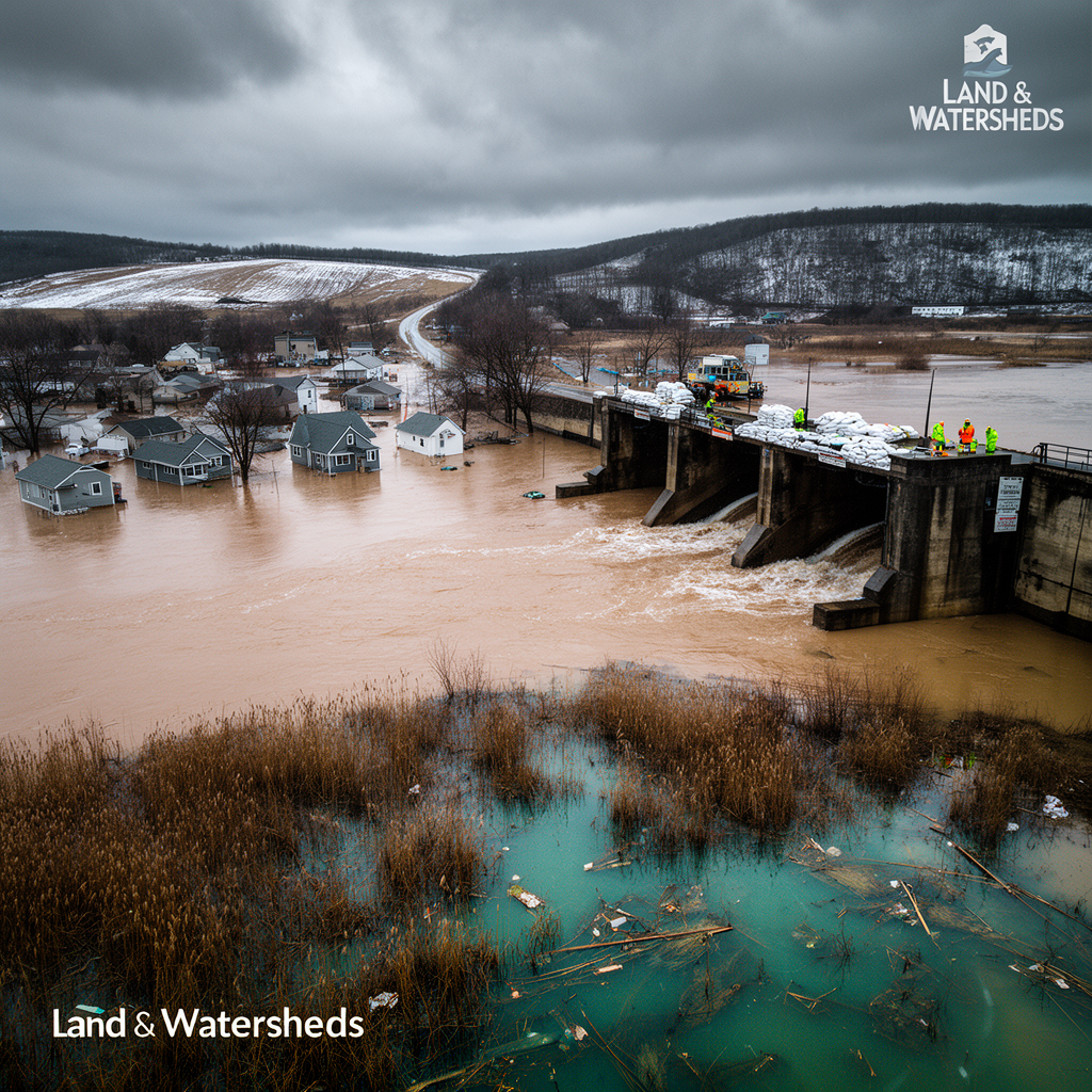
Floodplains are, from a certain perspective, extremely attractive real estate. They are flat, which reduces construction costs. They are often close to water, which has historically been important for agriculture, industry, and transportation. They are frequently surrounded by scenic landscapes. And in many regions, they were the first land to be settled, long before anyone had developed the analytical tools to understand the hydraulic risk they were accepting.
The result is that many of the world's most densely developed urban areas, including significant portions of Puerto Rico's coastal municipalities, are built directly on active floodplain. The fill permits have been issued. The roads have been paved. The buildings have been constructed, occupied, and insured. The political and economic barriers to relocating these communities are enormous. This is a real constraint, and pretending otherwise helps no one.
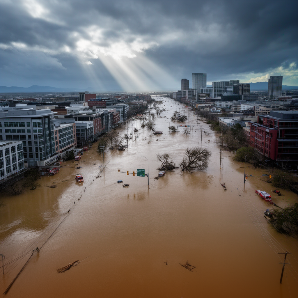
But the fact that floodplain development is widespread, historically rooted, and politically difficult to reverse does not change the hydraulic reality. The river's storage and conveyance needs don't disappear because we've rezoned the floodplain. They get displaced. When a river rises and finds its floodplain occupied by buildings, roads, and fill, the water that would have spread across that storage area has nowhere to go except higher in the channel, deeper in adjacent properties, and farther into the parts of the urban fabric that were never expected to flood at all.
The people most affected by this displacement are rarely the ones who made the development decisions. They are the downstream neighbors, the residents of slightly lower ground, the communities that were not protected by the levees that were built to protect the higher-value land upstream. Flood damage is never randomly distributed. It follows the hydraulic gradient, and that gradient was shaped by every fill permit and every channel modification that came before.
The traditional engineering response to floodplain development has been to attempt to contain the river: levees, concrete-lined channels, floodwalls, detention basins. These approaches are not without merit. They have protected real communities from real flood events, and in fully urbanized areas where relocation is not feasible, they are often the most practical available option.
But they operate against a fundamental hydraulic reality: the river's discharge hasn't changed. The water that used to spread across the floodplain has to go somewhere. Levees and channel modifications typically accelerate flow, increasing velocities and peak discharges downstream. The flood risk doesn't disappear. It moves.
The levee that protects one community often transfers and sometimes amplifies flood risk to the next community downstream. The channel lining that reduces travel time in one reach increases peak discharge at the next confluence. The cumulative effect of decades of individual flood control projects, each locally justified and each technically sound in isolation, can be a watershed-scale hydraulic system that is faster, flashier, and more damaging at its downstream end than the natural system it replaced.
This is not a criticism of the engineers who designed those projects. It is a description of what happens when you try to solve a watershed-scale problem one property at a time, without a framework for evaluating cumulative effects.
The shift that needs to happen, in engineering practice, in land use planning, and in public understanding of flood risk, is from thinking of floodplains as land that happens to flood occasionally to thinking of them as land that is hydraulically necessary for the river system to function.
From that mental model, the question changes. Instead of "how do we protect development in the floodplain from flooding?" the question becomes "what parts of the floodplain need to be preserved for the river system to function acceptably, and what parts can be developed with appropriate precautions?" That is a harder question. It requires watershed-scale analysis, long-term planning horizons, and political courage about where and whether to build. It also produces better outcomes than the alternative, which is to keep building in floodplains and keep being surprised when they flood.
The river is not attacking your city. It is trying to do what it has always done, in the space it has always used, with a water volume that we've spent a century increasing by paving its watershed. The appropriate response is not to keep trying to hold it back with increasingly elaborate infrastructure. It is to make room for it in ways that reduce, rather than transfer, the risk.
Floodplains were there first. They will be there last. The question is what we choose to put in them in between.
Q: Why are floodplains so flat?
A: Rivers created that flatness by depositing sediment during thousands of years of periodic flooding, the physical record of every time the river overflowed its banks.
Q: Can you build safely in floodplains?
A: Building in floodplains accepts hydraulic risk. The question isn't whether flooding will occur, but how often and whether the design accounts for it.
Q: What is a floodway?
A: The floodway is the portion of the floodplain that must remain clear to convey floodwater without substantially increasing flood levels.
Q: Do levees eliminate flood risk?
A: Levees reduce risk locally but often transfer and amplify flood risk downstream by increasing velocities and peak discharges.
Q: What should be preserved in floodplains?
A: Natural floodplain functions, storage capacity, hydraulic conveyance, and riparian buffers should be preserved where possible before considering engineered alternatives.